Changelog: CONTXT v1.0.2
Last updated: December 3, 2025
Released August 7, 2025
We're excited to share the latest improvements to Command Center, focused on giving you advanced location control, enhanced system stability, and a smoother user experience across all your logistics operations.
 What's New
Custom Stop Level Geofencing Control 
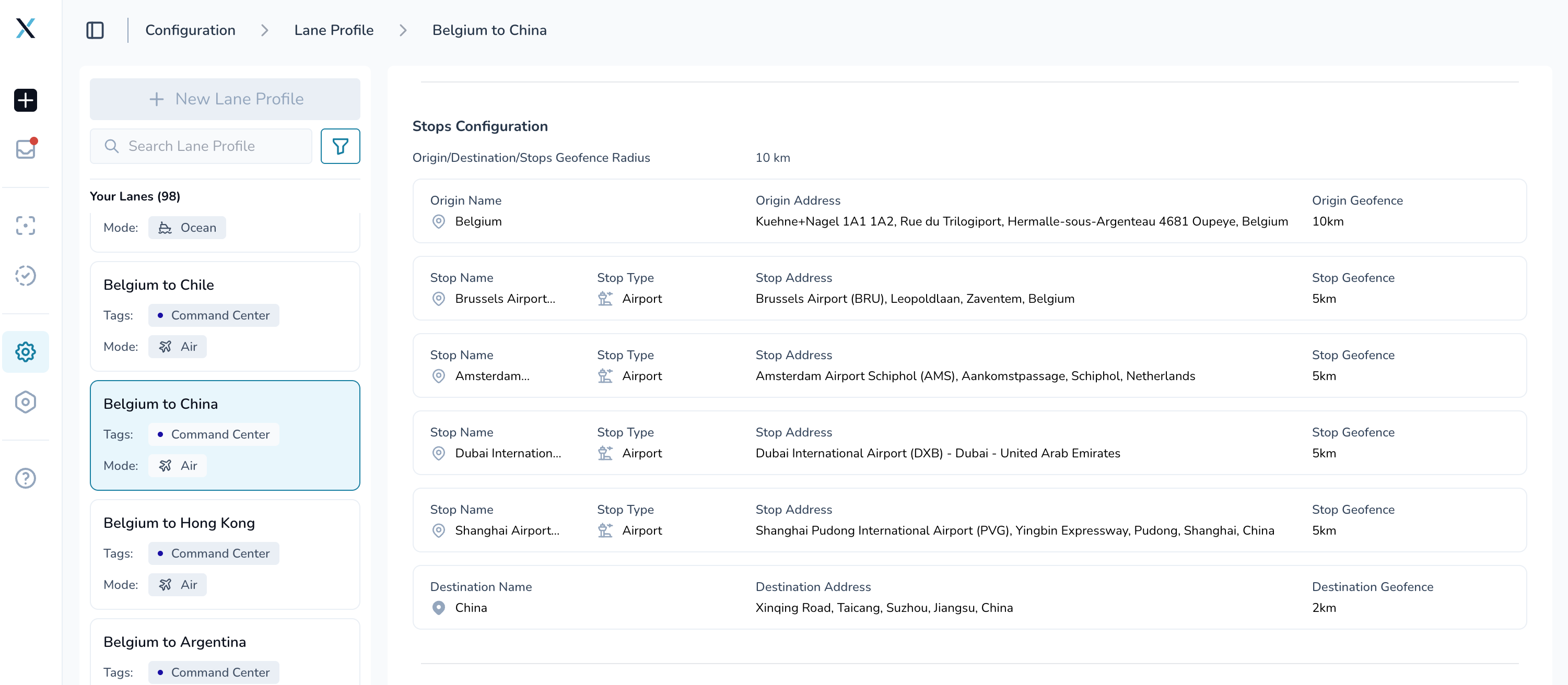
Precise control over each stop location
Individual stop geofences: Prevent geofence conflicts between nearby stops with tailored boundaries. Set a custom radius for each stop in your lane profiles instead of using one size for all
Seamless integration: All existing lane profiles work normally with the default geofence configuration (10km) and can be updated to have custom stop geofences going forward, while new ones can be configured with a custom geofence at the stop level
Why this matters: Get precise location tracking for complex routes without false alerts from overlapping geofences, especially in dense urban areas or industrial complexes.
Enhanced Tive Integration with Probe Data Support
Existing Tive integration is now enhanced to support probe data. The system automatically separates external and internal sensor data from dual-capability Tive trackers. Temperature probe data is processed independently while preserving complete telemetry context. Enhanced validation ensures only legitimate device data enters the processing pipeline, with independent data streams for each sensor type.
QuickStat Integration for Automated Shipment Creation
QuickStat integration automatically creates shipments from flight and logistics milestone data. The system maps tracking devices to shipments based on updates from Quickstat (milestone based shipment tracking is planned to be supported in the next upcoming release).
UPS Truckload SmartSheet Integration
UPS SmartSheet integration support for automatically creating shipments and updating shipment status (created + delivered) based on milestone changes. Real-time synchronization between UPS TL systems and Command Center with automated data validation and error handling for incoming spreadsheet data.
Enhanced System Reliability
More stable performance across all features
Fixed real-time updates: Resolved issue where device information could show incorrectly after switching between browser tabs
Favorite filter bug resolved: Favorite filters now work consistently without causing system errors or unexpected logouts
"Completed at" column sorting fixed: "Completed At" column now uses the correct timestamp and sorts properly
Better data consistency: Address information is now properly captured and stored from all geocoding sources
Document parsing support for single data logger XLS file exported from Sensitech desktop app.
 Improved Experience
Better Data Organization
Smarter sorting: Live shipments now use shipment ID as secondary sort, while completed shipments sort by creation date second
Accurate completion tracking: "Completed At" column now uses the correct timestamp and sorts properly
View downloads bug resolved: Download functionality now exports exactly what you're viewing, not the entire dataset
Enhanced view management: Fixed issue where "Add View" option would disappear after creating several custom views
 Behind the Scenes
System Improvements
Automated data management: New database triggers ensure lane profile route information is properly maintained
Enhanced geocoding: Better handling of international addresses with varying data completeness
Improved error handling: More graceful management of edge cases in filtering and data operations
 Getting Started
These improvements are automatically available in your Command Center dashboard. No action is required on your part.
Using Stop Level Geofences:
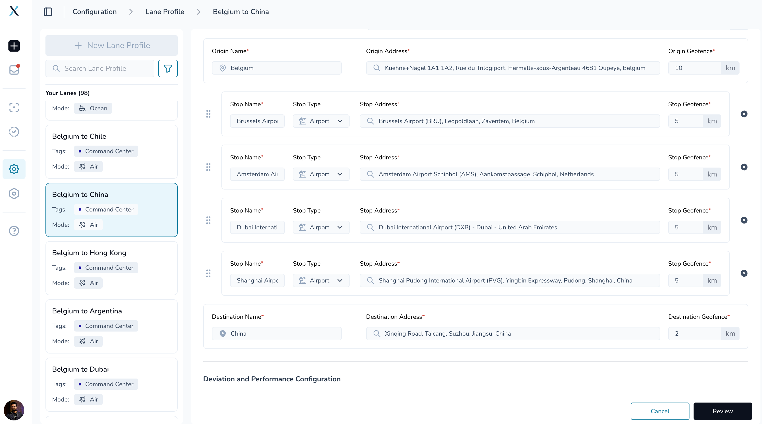
Create or edit a lane profile
Navigate to each stop configuration
Set a custom geofence radius for any stop that needs different boundaries
Global geofence remains as the default for stops, and if updated, will overwrite the stop geofences
 Tips & Best Practices
 Make the most of individual geofences:
Use smaller radii for stops in dense urban areas to avoid false alerts
Set larger radii for rural stops where GPS accuracy may vary
Consider the size of facilities when setting geofence boundaries
Review your existing lane profiles to identify stops that would benefit from custom geofences
 Need Help?
Questions about geofencing? Contact your Customer Success Manager for best practices guidance
Technical issues? Submit a support ticket through the help desk
Feature requests? Share your feedback through the in-app feedback tool
What's next? We're already working on document upload notifications and more UI/UX enhancements. Your feedback on the new geofencing capabilities will help shape our next release.
Thank you for using Command Center. We're committed to continuously improving your logistics management experience with powerful, reliable tools.